A list of Fishlake field names from old maps and documentary sources.
Field names.
Field names, like place names, have a fascination for local and agrarian historians because they can potentially provide information for our understand of the local landscape and its history.
In the past every field or piece of land was carefully named, unlike in more recent times when this practice became much less common. Before the age of maps naming farmed land was necessary and important for owners and tenants to clearly identify their property. For example, after the Enclosure Act (in Fishlake this took place in 1825) enclosed fields tendered to be called after their size or acreage. It is important to remember that pre enclosure open fields and commons did not have clearly defined field boundaries, e.g. with hedges and ditches. Therefore, many pre enclosure field names refer to strips or parts of land rather that a square or oblong piece of land that we think of as fields today.

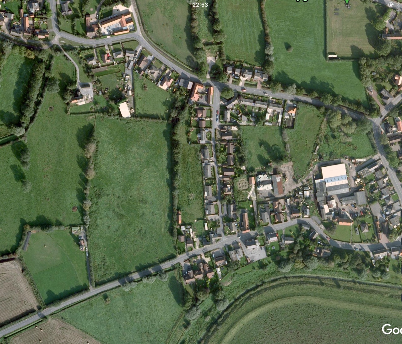
Fields at Fishlake today, with thanks to Google Earth.
Field names reflect the history, transition and agricultural practices over a very long period of time. There are clues to understand the nature of the soil, shape of the field, crops grown in the field, name of the owner or tenant, sports, functions, geographical nature and nicknames.
However, confusion can arise due to variations in field name spellings at different time. Also, some field had more than one name for example Southberry Croft, in the West End of Fishlake had three other names and could even be known by any other name according to a land deed.
The problem of identifying field name locations remains a problem partly because the size and structure of fields have changed over centuries, partly due to the lack of early maps and the practical problems of putting it all together in single format. The Enclosure Map of 1825 goes a little way to help identification but not many fields in Fishlake are named on the map. My Fishlake History Society colleague, Brenda Grafton, has gone some way to produce maps identifying more precise locations.
Records of over 300 field names are listed below. This work remains on going and it would be appreciated if anyone could help to add or correct this information.

Top a detail from the Fishlake Enclosure Map 1825.
Below the same area today with thanks to Google Earth.
Key to the main sources of these names.
Rental 1651. A rental dated 1651 related to the copyhold land held by the manor of Hatfield belonging to Isabell Steere daughter and heir to Thomas Perkin of Pinfold Fishlake. Original in Leeds Archives.
GB 1736. The Fishlake Grave Book 1736.
EA 1825. Enclosure Award and Map 1825.
EPN. The Place-Name of the West Riding of Yorkshire by AHSmith, part one, 1962. The examples from here are mainly derived from 1483 MinAcct 77.
BB Fishlake Bylaw Books.
JP 1680. Hatfield Manor Court Surrender of property from John Petty the elder of Fishlake to his son.
Information from Brenda Grafton who is also mapping Fishlake field names.
Other occasional sources will be separately named.
Alphabetical list of field names.
A.
Allerholme. 5 acres. GB 1736. A Close Situated South of Thorninghirst, North of Sour Lane.
Allworth Hill. East Field. Manor of Stockholds, Fishlake 1639. Reference in Bylaw Book 1716.
Anaball Hill. 5 roods. GB 1736.
Annis Ing. 2 acres 3 roods. GB 1736.
Arnall Ing. Next of joining South Lane. 3 acres. GB 1736.
Axlemoor. West Field. GB 1736.
B.
Bakerseying. EPN. (bakere is baker, perhaps a surname, eng is meadow).
Balden Croft. 5 acres 1 1/2 roods. GB 1736.
Ban Croft. 1 acre. GB 1736.
Bank Ing. 12acres 2 roods. Including 5 roods in Bank Ing upon Parson Garth. GB 1736.
Barcroft. East Field. Reference in Bylaw Book 1716. 5 acres 7 perches. OS map no 525. Source Clough House sale papers 1937.
Bareshanks. 3 acres. GB 1736.
Barnett Flatt, East Field. GB 1736.
Barstowcar. 2 acres. Will of John Parkin 1609.
Beamont Garth. 1 acre, 5 1/2d. Rental 1651.
Bell Green Pighill. 1 acre. GB 1736.
Birksikes. 2 acres 1 rood. GB 1736. Also mentioned in a Decree of Commission of Charitable uses 1615. 4 acres there for the maintenance of the Fishlake Almshouse.
Black Abbey Garth. 1 1/2 roods with Edifices. Fosterhouses. GB 1736.
Black Croft. 7 acres 2 roods. GB 1736.
Blackshaw Lane Close. EA map situated South and adjacent to Blacksyke Lane.
Botilgartho. EPN.
Brackenhill Croft. 4 acres. See Wetsells. GB 1736.
Brittain See Far and Near.
Broad Croft at Thorninghirst near North Lane 4 acres. GB 1736.
Broadmans Croft. Hon John Simpson 7 a 3 r 0p, rate 3s 10 1/2 d. EA map no 627.
Brown Croft. EA map situated West and adjacent to Wood Lane. Referenced in a Church Court tithe (firewood) dispute of 1587. See in Church Court article.
Brown Garth near Micklehirst at Thorninghirst. 1/2 acre. GB 1736.
Brown Hill Close. Situated near Snelsholme Lane see EA map 1825.
Brown Hill Ings. 2 1/2 acre. GB 1736.
Botilgarth. EPN. (Bothildr personal name, enclosure).
Boulanger Ing. see Catfleets.
Buckrams Close. EPN (Glebe Terrier 1764). See EA map Situated South of Carr Head Lane. Probably the same Bukran Close mentioned in 1546, Yorkshire Chantry Chapel Survey, Surtees Society vol. 2 1894.
Buildmires. 1/2 acre, 2d. Rental 1651,
Bulan Ing in Catfleets. 2 acres. GB 1736.
Burkin Croft. EA 1825.
Burngate. From Mellish Deeds of 1704 no 1.
Butler Garth and Ing. 1 acre in Butler Garth and 2 acres in Butler Ing. GB 1736. See EA map 1825. Situated north of Trundle Lane.
Bylaw Garth. 5acres 2 roods. GB 1736.
Byre Croft or Gamble Croft. 5acres 1/2 rood. GB 1736.
C
Calf Garth. EA 1825 see M11 no 10. Sykehouse?
Catfleets Ings. 1/2 acre. GB 1736.
Catfleets. 6 acres 1 rood. Including 1 acre upon Zeming in Catfleets and 2 acres in Bulan Ing in Catfleets and 1 acre in Bulan Ing Hern. GB 1736. Referenced as Catflette in Bylaw Book 1582.
Chapman Garth. 2 acres 3 3/4 roods. GB 1736.
Clay Croft. 1 1/2 acres. GB 1736. In Mill Field Samuel Staniland 4 acres 1 rood 15 perches, rate 1s 1d. EM 1825, no 466
Clay Field, Mill Field. GB 1736.
Clay Flatt, Mill Field. GB 1736.
Clay Lands, Mill Field.
Clay lands, East Field. 1/2 acre, 2d. Rental 1651.
Coates, Mill Field. GB 1736.
Coates, East Field. GB 1736.
Coates Balk, Mill Field.
Coates Croft. 6 acres. GB 1736.
Coats Flat, East Field. Same as Coates above. Accounts of Allen's Charity lands 1805.
Coat Lidgit, Mill Field. 1 rood, 1d. Rental 1651.
Cobdall Flatt. 3 roods. GB 1736.
Cootes. 1 rood, 1d. Rental 1651.
Crookness, Mill Field. 1 rood situated in Windmill Field JP 1680. Referenced in Bylaw Book 1716.
Curtice Croft alias Crook Croft. 3 acres 2 1/2 roods. GB 1736.
D.
Dastard Croft. 1 acre. GB 1736.
Dickins Croft. 1 acre 1 roods. GB 1736.
Dikeholmes. 1 acre. GB 1736.
Dike Ing see Northholme.
Dick Ing on Nab. Referenced Bylaw Book 1716.
Dons Pighill. 2 acres 1/2 rood. GB 1736.
Dormer Croft. 4 1/2 acres and 2 acres in a Pighill there. GB 1736.
Dormer Ushells. 7 acres and 2 acres being upon Fen Lane. GB 1736.
Dunghill, Foster House Field.
Dunghill and Hern, Mill Field. Manor of Stockholds 1620. GB 1736.
E.
East Ing upon South Lane. 3 roods. GB 1736.
East Ing, East Field. GB 1736.
East Ings Close. 2 acres 2 roods 35 perches. Situated close to North Lane and Sour Lane. Source JJ Spencer estate sale papers 1915.
East Toft. 2 1/2 acres. GB 1736.
Erlesyng-Lath. EPN. (the earl's meadow and barn).
Evat Croft. 8 1/2 acres 2 roods, including 1/2 acre and 1/2 rood in a toft there. GB 1736.
Evott Croft, a close JP 1680.
F.
Fall tharrow. 3 acres 3 1/2 roods. GB 1736.
Far Brittain. Ann Spooner and Mary Blanchard. 3 acres 1 rood 10 perches, rate 1s 6d. EA 1825 no 260.
Far Jockey Close. Mary Holdsworth, 5 acres, rate 3/4d. EA 1825 no 458.
Far Sparrow Croft. EA map no 197, situated South of Wood Lane at Thorninghirst.
Fencarr. 1 acre, 6d. Rental 1651.
Fen Close. 1 acre 1/2 rood. GB 1736.
Fen Hill. 5 roods. GB 1736.
Fen Laine End. 1 1/2 roods. GB 1736.
Fenlondend. EPN. (fen land end).
First Stapleton Close. Hon John Simpson, 5 acres 2 roods 37 perches, rate 2 s 5 1/4d. EA 1825, no 608.
Fisher Croft. 5 acres 2 roods 14 perches, 1786 Estate Survey. In 1825 John Hunt, 4 acres 1 rood 18 perches, rate 1s 10 1/4 d. EA no 270a. Situated North Sour Lane.
Fleming Croft next Micklehirst. 1 acre. GB 1736. In 1786 2 acre 31 perches, Estate Survey.
Foreshore, Fosterhouses. 1 acre 1 rood 8 perches. Deed of Thomas Smith of Smallhedges 1854.
Foster House Field. Foster Houses.
Freshellis, a close. Will of John Parkin 1609.
Friend Garth, a toft. 1/2 acre. GB 1736.
G.
Gaitshadles. ENP. Yorkshire Wills 1564. (a cross- roads). See EA map Gate Shaddles situated corner of Sorrell Lane and Hayes Lane.
Gamble Croft see Byrk Croft.
Garnors Close.18 acres abutting Double Dike to the North and Nortonfield Lane to the West. Deed of 1783. Deeds at Wakefield Registry.
Garnar Croft. EPN, Min Act 1541. (surname Garner, Croft).
Gap Acre see Mickle Fen.
Geesness see Northolme.
Gen Croft and Stockin. 7 acres in one close but heretofore in two close called Gen Croft and Stockin. Sykehouse Parish Records, Manor Court Rolls of Hatfield (copy) 1777. Is this Fishlake?
Germain Lane Flat. Accounts of Allen's Charity lands 1805.
Glead Croft. 1 rood. GB 1736.
Goteln Gayte. 1 rood, 1d. Rental 1651.
Great Ushells. 6 acre. GB 1736.
Great Thorninghirst Croft. 4 acres 3 rood. GB 1736.
Greekholmes. 3 1/2 acres 1/2 rood. GB 1736.
Green Close. EA map situated on corner of Geeseness Lane and Blacksyke Lane.
Gun Croft. 14 acres 1/2 rood, including 2 1/2 rood in Low Gun Croft and 1 rood in Nagg Pighill upon Guncroft.
H.
Hadds see North and South. Land situated North of Thorne between the Selby Road and Dikesmarsh. Hadds meaning Headland (often untilled land or common). Referenced in JP 1680.
Hallworth Hill, East Field. 1 acre, 4d. Rental 1651.
Havering at the Garth end. 2 acre. GB 1736.
Hayes, an enclosure. Hayes, Haga 1343 EPN, Mentioned in 1546 Yorkshire Chantry Chapel Survey Surtees Society vol 1 1894.
Hayes Close, situated off Hayes Lane, see EA map 1825.
Hayes Lane Field. 5 acres 3 roods 30 perches. Situated West of and fronting Wood Lane, OS map no 472. Source The Old Hall sale papers 1937.
Hays. 1 acre 3 1/2 roods. GB 1736.
Hazlehirst Close, situated close to Hayes Lane, see EA map 1825.
Hazel Hurst. 6 acres 2 perches. OS map no 106. Source Clough House sale papers 1937.
Hedes, a close. Will of John Parkin 1609. Could be same as Hadds.
Hessell, Mill Field. 1 1/2 roods, 1 1/2d. Rental 1651.
Hessle Flat, Mill Field. GB 1736.
Hesslehirst. 2 acre 1 rood. GB 1736.
Hessle Hirst Shaw. 1 acre 3 roods. GB 1736.
Heymires. 2 1/2 acres 1/2 rood. 2s 7 1/2d. Rental 1651.
Hob Croft. 2 acres. GB 1736.
Hobson's Croft. 2 acres 2 roods. Situated near Hay Green Farm. Source JJ Spencer estate sale papers 1915.
Hoggreue (Hog wood). EPN.
Hollinbush flat. Account of Allen's Charity lands 1805.
Hollingbush Flatts. As above. Manor of Stockholds, Fishlake 1688.
Hornby Croft. 2 acres 1/2 rood. Close to Hornby Lane. GB 1736.
House Close. Estate maps of William Payne , 1801.
Hud Croft. Will of Richard Clerk 1500. Born in Fishlake.
Hud Pighill near Webster Croft. 1/2 acre. GB 1736.
Howlands. 2 acres 3 roods. GB 1736.
I.
Ichynenge. EPN, Min Acct 1405.
Ings Siddles on Steward Ing. Referenced in Bylaw Book 1716.
Inkle Moor. 29 acres 2 roods. GB 1736. Mentioned in Rental 1651. Detached lands, located North of Thorne.
J.
Jack Croft. 5 1/2 acres. GB 1736.
Jannett Croft. 1 acre 1 rood 24 perches. Situated close to North Lane and Sour Lane. Source JJ Spencer estate sale papers 1915.
Jemmill Croft. Mathew Amery 1 acre 1 rood 25 perches, rate 9 1/2d. EA 1825 no 267. North of Sour Lane.
Jenkin Croft and Shaw. 14 acre. GB 1736. Also mentioned in 1651.
Jockey Close. Mary Holdsworth 2 acres 2 roods 24 perches, rate 1d. EA 1825 no 450.
Jocky Flatt. Article of agreement between Richard Doughty and Edward Womeley, 1675. Sheffield City Archives.
Jordan, East Field.
Johnny Hall Close. Adjoining Johnny Hall Lane.
K.
Kinward Croft, Foster House Field. GB 1736.
Kirk Town. 3 acres including 1/2 rood in West Garth and 3 roods in one toft there. GB 1736.
Knight Croft, next or butting upon Osgteshalls. 2 1/2 acres. GB 1736.
L.
Laine House. 2 1/2 roods in a Garth there. 7 roods with the buildings at Laine House 3 1/2 acres formerly with the buildings at Laine House. GB 1736.
Land Croft at Foster houses. 1 1/2 acres. GB 1736.
Land Herne Shaw. Mellish Deed of 1704, no 1. ???? Check.
Laverack Shaw. 2 acres. GB 1736. Laverack is a personal name.
Lawns. Situated South of Sour Lane, see EA map 1825, no 104.
Le Heth. (Heathland). EPN.
Ley Ings. 1 1/2 acres. GB 1736.
Les Halues. (Half acre or hath 'nook'). EPN.
Little Close. Mathew Amery 1 acre 36 perches, rate 5d. EA 1825 no 272.
Little Hayes Close. EA map situated West and adjacent to Wood Land and East of Brown Croft.
Little Martin Ing. Just to the East of the Fishlake vicarage. 1752 Lord Viscount Irwin Inquest Map.
Little Woolf Hill. 4 acres. GB 1736.
Long Buall, West Field. GB 1736.
Long Croft. 5 acres 1 rood. GB 1736. Also Longcroft ( also known as Wood Lane Close). 3 acres 1 rood 33 perches. OS map no 102. Source Clough House sale 1937.
Long Whitehouse Garth. EA map adjacent to Wykehouse Lane.
Lord Croft, Fosterhouses. 4 acres 2 perches. Deed of Thomas Smith of Smallhedges 1854.
Low Close, Far and Near. West Field. Source Estate maps of William Payne, 1801.
Lowghwhaites. 5 acres. GB 1736.
M.
Malkin Croft and Malkin Ing. 2 1/2 acre, plus 1 rood with the buildings there. Also 2 acres in Malkin Ing joining upon Snelsholme Green. GB 1736.
Martin Ing. East of Fishlake vicarage. Reference in Bylaw Book 1666. Also on Lord Viscount Irwin Inquest Map 1752. See Mertyeyng.
Mastall Pitt, (or Marshall Pitt), 1/2 acre, Mill Field. GB 1736.
Mastill pit flat. Accounts of the Allen's Charity lands 1805.
Mellon Ing. 2 acres 1/2 rood. GB 1736.
Mertyeyng. EPN Pat. 1405.(Martin Ings).
Macklemore Croft. 1/2 acre. GB 1736.
Macklemore Fen. 26 acres 1/2 rood including 1 acre on Gap Acre. GB 1736.
Medley Close, Fosterhouses. deed of Thomas Smith, Smallhedges 1854.
Mentoft. A little Close, East of Hornby Lane. John Cowley deed 1733. Deeds Wakefield Registry.
Middle Flatt. 1 acre. GB 1736.
Midlemires. 2 acres, 2s. Rental 1651.
Micklehirst. 4 acres 2 1/2 rood. GB 1736. In 1825 Ann Spooner and Mary Blanchard 4 acres 2 rods 24 perches, rate 1/4d. EA 1825 no 274.
Mill Close, Far and Near. Estates maps of William Payne, 1801.
Mill Land Field, Mill Field Road. 13 acres 1 rood 29 perches. J J Spencer estate sale papers 1915.
Milner Croft. 13 1/2 acres. GB 1736.
Mocock Croft. 1 acre 1 rood. GB 1736.
Molendin Stapuland. (a mill for sorting wool). EPN Min. Acct 1324.
Moor Croft. 11 acres 2 rooms. GB 1736. Situated off Hayes Lane, see EA map 1825.
Moor house Gate the buildings. 1/2 acre with buildings, 3 rooms with Edifices, 1/2 acre 1/2 rood with the buildings, 1 acres with the buildings, 1 acre with the buildings. GB 1736.
Moor Ing. 9 acres 2 1/4 roods, including 2 acres and 3 1/2 rods in Moor Ing on Lowhitts. GB 1736.
Mortenstall, East Field. GB 1736.
N.
Nab Close. 2 acres 3 roods 3 perches. Situated in Hornby Lane. Source JJ Spencer estate sale papers 1915.
Nab Field. 1 acres 2 roods 26 perches. Source JJ Spencer estate sale papers 1915.
Nab Ing. 1/2 acre. GB 1736.
Nag Pighill. 1 rood in nag Pighill upon Gun Croft (see Gun Croft). 1 rood in Nagg Pighill near Gun Croft. 1 acre in Nagg Pighill butting upon Snelsholme. 1 acre 2 roods in Nagg Pighill (no place specified). GB 1736.
Nan Croft. 4 acres. GB 1736. See EA map situated South of and adjacent to Wykehouse Lane.
Near Brittain. Ann Spooner and Mary Blanchard, 2 acres 2 roods 18 perches, rate 11 1/2d. EA 825 no 296.
Near Sour Lane Close. EA map situated North of Sour Lane.
North Buall, West Field.
North Croft called Court Laine Shaw. 7 acres. GB 1736.
Northern Pighill, Thorninghirst. See EA map 1825. Situated South of Steward Ings Lane
Northern Wood, Thorninghirst. See EA map 1825. Situated South of Steward Ings Lane.
Northfield called New Croft. 11 acres. GB 1736.
North Hadds. 17 acres. GB 1736.
Northholme. Mentioned in the Probate Inventory of William Clarke 1702.
Northolme. 29 acres 1 rood, including 17 acres in Northolme, 8 acres in Dikeing, 3 acres in Geeness, 1 acre in Northholme Hill. GB 1736.
North Holme Hill see Northholme.
North Lane Close. Mathew Amery 5 acres 2 roods 36 perches, rate 2 s. EA 1825 no 271.
North Lane Croft. 8 1/2 acre 1 rood. GB 1736. In 1825 Mathew Amery 3 acres 1 rood 26 perches, rate 1s 3/ 4d. EA 1825, no 192.
North Lane Shaw. 2 acres. GB 1736.
O.
Old Field, Mill Field. Will of John Hague 1725.
Old Field Flat, Mill Field. Accounts of Allen's Charity land 1805.
Old House Garth. EA map situated South of and against to Clay Dike at Bell Green.
Old Lowns. 8 acres. GB 1736.
Osberton Croft, next to Allworth hill in East Field.
Osburn Croft in Allworth Hill. JP 1680.
Outcaster Croft. 2 acres a close. SP records, Manor Court Rolls of Hatfield 1777, mentioned in 1708. Is this Sykehouse?
Oxoxs or Oxoake. 16 acres. GB 1736.
P.
Page Pighill. 1 acre 1 rood. GB 1736.
Pains Croft. 13 acres, including 1 rood in a Shaw joining upon Pains Croft. GB 1736.
Parson Croft, West Field. Reference in Bylaw Book 1702.
Parson Garth, see Bank Ing.
Peacock Ing. 3 acres. GB 1736.
Peacock Shaw. 3 acres 3 roods. GB 1736.
Person Pighill see Snow Croft.
Penny Shaw. 6 acres 2 roods. GB 1736.
Pickhaver Shaw. 1 acre. GB 1736.
Pickhill. Estates maps of William Payne, 1801.
Pig Close. EA map situated South Carr Head Lane, next Buckram Close.
Pighill near or upon Allworth hill. 2 1/2 roods near Allworth hill, 2 acres butting upon Allworth hill. GB 1736.
Pighill next Gun Croft. 1/2 acre. GB 1736.
Pighill Close. 2 acres 8 perches. Situated near Hay Green Farm. Source JJ Spencer estate sale 1915.
Pinfold Pighill. The name of the present allotments on Pinfold Lane source Mis Olive Smith.
Place Ing. 1 acre 3/4 rood. GB 1736. Is this Sykehouse?
Poor Folk's Close. Part of the Fishlake Poor Estates. Dating back to a bequest of Thomas Parkin in 1574. Reference Charity Commission Report 1895
Poor Ing. 3 acres. GB 1736.
Press Ing upon South Lane. 1 acre 1 rood. GB 1736. Is this Sykehouse?
Priest Croft Hill. 1 1/2 roods, West Field. GB 1736.
Pylkyngton. EPN.
Q.
Queensholmes. 6 acres 3 roods. GB 1736.
Quinter House Shaw. 2 acres. GB 1736.
R.
Rawgate Croft at Thorninghirst. 3 1/2 acres with the buildings, 2 1/2 acres with the buildings. GB 1736.
Rawgate Ing in South Hadds. 3 acres 1 1/2 roods. GB
1736.
Raw marsh. 10 1/2 acre. GB 1736.
Redhill. 2 acres, 8d. Rental 1651.
Redynges. Will of John Parkin 1609.
Reed hill. 5 acres. GB 1736. Reedhills EA map situated South of Blacksyke Lane.
Riding Gap. 1 rood near to in West Field. GB 1736.
Roger Close. Situated near Snesholme Green see EA map 1825.
Round half acre. 1/2 acres on Wettfurrs. Referenced in Bylaw Book 1716.
Round Rood. 1 rood. Referenced in Bylaw Book 1716.
Rudgates, next Burnleys. 1 1/2 acre. GB 1736.
Rue Croft. 6 acres, including 2 roods butting upon Rue Croft. GB 1736. Rue is a herbaceous plant often used as a disinfectant.
Rue Croft, West Field. Referenced in Bylaw Book 1716.
Ryley Garth, Mastall Pitt. Manor of Stockholds 1694.
Rysam Bridge Pighill. 2 acres 1 rood. GB 1736.
S.
Salmon Bowers. 7 roods. GB 1736.
Salmon Moor. 4 acres. GB 1736.
Sand Croft. 7 1/2 acres, including 1 1/2 acres with buildings. GB 1736.
School Close. EA map situated North of Wood Lane.
School Close, Claybridge. Little 1 acre 2 roots 11 perches. Middle 2 acres 2 roods 17 perches. Far 2 acres 2 roods 11 perches. Far 7 acres 18 perches. Middle 4 acres 1 rood 32 perches. Near 6 acres 1 rood 24 perches. Fishlake School Trust lands in 1894.
Scoots Close. From c 1700 Charity Commissioners report of 1895 when Paul Holme was tennant. 1 acres 3 roods 2 1/2 perches this is the moiety. Situated at Foster House between Wenchurst Lane and Sorrell Lane.
Second Stapleton Close. Hon John Simpson, 6 acres 1 rood 2 perches, rate 2s 9 2/4d. EA 1825, no 609.
Shading Garth. 1/2 rood. GB 1736.
Shaw Croft. 3 acres. GB 1736.
Sheppinstall, West Field. JP 1680.
Shepenstall Long and Short, East Field. Referenced in Bylaw Book 1716.
Short Croft, Foster house Field. GB 1736.
Sholtberrycloses. EPN 1541 Min Acct.
Shutter Ing. 2 acres. GB 1736.
Sil Croft at Thorninghirst. 3 1/2 acres with buildings. GB 1736.
Simon House joining upon Norton Field. 1 acre. GB 1736. (This could be what in the EA map Old House Garth, see under that.
Simond Land or Simon or Simson Lands. 3 acres 3 roods. GB 1736. EA map Simeon Land Close next to Bell Green.
Simon Lands, Claybridge 5 acres 16 perches. Fishlake School Trust lands 1894.
Slate Garth. West Field. Referenced in Bylaw Book 1716.
Slethorne. EPN. (level field).
Smith Ings, West Field. GB 1736.
Smith Moor Croft. 3 acres 2 roods. GB 1736.
Snaith Ings. 3 roods. West Field. GB 1736.
Snatchells. 6 acres 7 roods. GB 1736.
Snow Croft. 3 acres 1 rood, including 5 roods in Parson Pighill in Snow Croft. GB 1736.
Sorrel Croft, West Field. 1 acre, 4d. Rental 1651.
Sorrel Flatt, West Field. JP 1680.
South Benall. 1 rood. West Field. GB 1736.
South Buall, West Field. 1 acre, 4d. Rental 1651.
South Hadds also see Rawgate Ing. 25 acres 1/2 rood, including 3 acres and 1 1/2 roods in Rawgate Ing there. GB 1736.
Southberry Crofts or Sandbed Crofts otherwise Black Crofts otherwise Long Closes or by any other name. 2 closes containing 8 acres. Deed of John Cowley 1733. Deed Wakefield Registry.
St Hugh Croft. Source Mellish Deeds of 1704, no1.
Stapleton. see First and second.
Staynthorp. EPN 1329 AD.
Steward Ing. Referenced in Bylaw Book 1716.
Stockin see Gen Croft.
Stock Ings. 2 acres 3 1/2 roods. GB 1736. More recently part of the Dole Charities lands.
Stonyknoll. EPN 1541 Min Acct. (hillock).
Struns Croft. 8 acres. GB 1736.
Studards Garths, a close. Will of John Hague 1726.
Symond Ing. 1 /2 acres. GB 1736.
T.
Tendrill Croft, Foster House Field. GB 1736.
The Garth Field. 1 acres 2 roods 34 perches. Situated near Hay Green Farm. Source JJ Spencer estate sale papers 1915.
Thorninghurst Close. Mortgage from Robert Wayte of Selby to Francis Simpson of Fishlake 1786. Sheffield City Archives.
Thorninghirst Croft. 3 1/2 roods. GB 1736.
Threshalls. 1 1/2 acres. GB 1736.
Thuscroft, West Field.
Town Croft. 7 acres 3/4 rood. 1 rood with buildings. 1 acres and 1/2 rood with the buildings. 1/2 rood with the buildings. 1 1/2 roods with the buildings. GB 1736.
Town Ings. Referenced in Bylaw Book 1582. 21 acres 2 1/2 roods. GB 1736.
Turn Croft. Land and buildings near Taining Lane see EA map 1825.
Twelve Apostles. Part of the Thomas Allyn the Elder charity lands containing 12.89 acres. Hence the name.
Tyanfall. 1 acres. GB 1736.
TytheDale. EPN 1771 m.
W.
Wad Croft near Foster House Green. 1 acre. GB 1736.
Walkin Garth, Moorhouse. 1 1/2 rood. GB 1736.
Wallnut Croft. 2 1/2 acre. GB 1736.
Walnut Tree Close. Records regarding changes of ownership from 1707. Church records due to ownership of Rev John Gibson.
Wallnut Tree Pighill. 1 1/2 acre close at West End of Fishlake. Will of John Hague 1725.
Webster Croft, Foster House Field.
Wellis Garth. Will of John Parking 1609.
Wench hurst Close. 2 acres 1 rood 15 perches. Source deeds belonging to Fishlake Hall dated 1810. Also Wenchurst Field, 5 acres 19 perches. Situated South of Sorrell Lane, Fosterhouses. OS map no 534. Sources The Old Hall sale papers 1936.
Wenshirst. 3 acres, 2s. Rental 1651.
West End the buildings.
West End Close or West End Croft. Deed of 1733. Deeds Wakefield Registry.
West End Croft. 3 acres 3 rood in 1736.
West Field Closes, West Field. Mentioned in 1546 Yorkshire Chantry Chapel Survey Surtees Society vol 1 1894.
West Field Gate, West Field.
West Garth. see Kirk Town.
West Noake on Steward Ing. Referenced in Bylaw Book 1716.
West Toft. 3 roods. GB 1736.
Wetsells called Black Croft. 6 acres, 2 acres in Wetsells. GB 1736.
Wet setts or Wetwhongs. 9 acre 3 roods. GB 1736.
Wettfurrs. Referenced in Bylaw Book 1716. 1 rood, East Field. GB 1836.
Wett-honeys. 5 acres 3 roods. GB 1736.
White Clover Field. 7 acres 3 roods 19 perches. OS map no 61. Source Clough House sale papers 1937.
Wheat Croft. EA map situated at Foster houses adjacent Hussells Lane.
Wikehouse. 7 acres 1 rood, including 2 acres and 3 roods in Balden Croft Wikehouse. GB 1736.
Willcoat Bank, East Field. Referenced in Bylaw Book 1716.
Will Croft a moor. 2 acres 1 rood. GB 1736.
Willoke or Wylocke or Willocke, West Field. JP 1680.
Wolsum Ings. 15 acres 1 1/4 rood. FB 1736. EA map situated South and adjacent to Blacksyke Lane. Same as Wollsomyng, 2 acres in Will of John Parkin 1609. Now 2 acres West side of Low Ings Lane?
Wood Lane Close. See Longcroft.
Wood Lane Field. 3 acres 2 roods 11 perches. Situated East of with a frontage to Wood Lane. OS map no 474. Source The Old Hall sale papers 1937.
Y.
Youl Croft. 8 acres 3 1/4 rood, including 1 rood in Youl Garth. GB 1736.
Z.
Zeming see Catfleets.
Glossary of terms.
Close. An enclosure from an open field.
Croft. Enclosed meadow or arable land, usually adjacent to the house.
Field. The present day fields are more properly closes. Before enclosures a field was a large stretch of open land divided into strips.
Flat or flats. A strip in an open field or a piece of level ground.
Garth. A yard or enclosure.
Hayes. An enclosure.
Hern. An odd shaped, small piece of land or land in the bend if a river.
Ings. A common meadow.
Land. A Selion.
Lawn. A Selion
Ley. A meadow, untilled land.
Perch. A very variable size in feet. Later standard end to 16 1/2 feet.
Pighill. Small enclosure, Croft.
Rood. 1/4 of an acre.
Selion. A cultivated strip in an open field, con sting of a ridge with a furrow on either side.
Shaw. A small wood.
Toft a house or the land were a house once stood.
Rob Downing May 2020.